On the super-continent of Pangaea, there were no children throwing rocks into the water off High Bridge. There were no men and women dancing on the Falls City paddlewheel, no grandmothers shouting “amens” from the front pew of the Union Church. There were no houses, no religions, no railroads, no 40330 zip code, and no destinations on the map. Just a place on earth—an area of rock and sand swirling and resettling beneath the calm, warm waters of an ancient inland sea. At that time, nearly half a billion years ago, Baltica (the continent of Europe) was drifting closer to ancient North America, and the ocean floor separating the two masses was slowly subducting beneath the North American continental shelf, pushing up a chain of very steep and extremely tall mountains, the Appalachians. As the continents buckled, the inland sea gradually retreated to the west, leaving a network of ancient rivers flowing out of the mountains across a marshy plain (in present day Ohio and Indiana), emptying at last into this ever-shrinking, ancient body of water at a point north of Madison, Indiana, much farther north and east of its present confluence with the Ohio River at Carrollton, Kentucky (Ellis 39). What is now the Kentucky River was but a tributary of the larger ancient Teays River system that passed through a tropical paradise of dense rain forests, swamps and marshlands. At that time, the geographical area we know as the state of Kentucky lay squarely on the Earth’s equator. Over the course of hundreds of millions of years, after tectonic shifts further meted out the continents, the Cincinnati Arch (a geological upheaval in central Kentucky beginning in the Pliocene epoch 10 million years ago and lasting until the Pleistocene epoch some 600,000 years ago) and the cyclical grind of glaciation redirected the Kentucky River’s flow (Ellis 1), integrating it with the early Ohio River, and creating the course of the river as we know it today: a deep meander, winding from its headwaters in southeast Kentucky northwest to its mouth at the Ohio River.
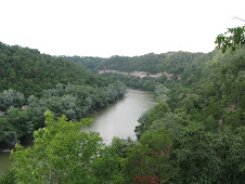
Anyone who has experienced the Kentucky River, particularly between Lock & Dam seven and eight, has seen firsthand, the dramatic result of 500 million years of water leaving its mark on a place. The palisades section of the Kentucky River, with its 300 foot cliffs of Ordovician limestone, is not only of great geological import; the layering of human presence has left a mark on this place every bit as profound as the river itself, displaying the evolution of humankind’s conceptualization of our place in relation to the natural world. Written into this landscape of sheer cliffs, forested bluffs, open bottom-land and cool hollows hidden in shadow, is a catalogue of human responses, spanning eons, to the incredible forces of nature. Sometimes the human response has been one of wonderment and awe, or humility, or respect, or even fear. At other times, the response has been arrogance, vanity, vulgarity, disrespect, and even contempt for nature, for the environment—for this place.
Subscribe to:
Post Comments (Atom)


No comments:
Post a Comment